Mainstream News has become the Band on the Titanic.... Alternative, Breaking, World News that Reports what the Mainstream Media Ignores. Welcome to "The Honest Intelligence" Please see Copyright information at bottom of page...
(NaturalNews) Keeping up with the latest science regarding chemical safety is apparently of little or no concern to the Canadian government, which recently declared the highly-toxic plastics chemical bisphenol-A (BPA) to be safe just two years after declaring it to be a toxin. In a report issued by Health Canada's Food Directorate, the agency has iterated its unfounded position that exposure to BPA in food packaging "is not expected to pose a health risk to the general population, including newborns and young children."
The announcement is curious as Canada was one of the first countries to question the safety of BPA back in 2008, right around the time that emerging science began to show that the chemical leeches out of containers and into food and drinks. A Canadian government panel at that time had determined that BPA is potentially linked to hyperactivity in children, breast and prostate cancers in adults, and birth defects in newborn babies, among other conditions, which led many product manufacturers to voluntarily phase out the use of BPA.
"Our science indicated that bisphenol-A may be harmful to both human health and the environment and we were the first country to take bold action in the interest of Canadians," said Canadian Health Minister Leona Aglukkaq in a statement back in 2010.
But in typical wishy-washy fashion, these same corporate-backed bureaucrats are now back-peddling by trying to claim that BPA is just fine, even for infants and babies. In complete denial of copious amounts of evidence showing that even low levels of exposure to BPA can cause organ damage, developmental disorders, reproductive damage and infertility, digestive dysfunction, DNA damage, endocrine disruption and many other conditions, Health Canada is attempting to pull the wool over the eyes of the public by blatantly kowtowing to the chemical industry.
Th U.S. Food and Drug Administration (FDA) has also flip-flopped several times on the BPA issue, having recently banned BPA from children's drinking cups after vehemently denying a few years earlier that BPA was at all dangerous (http://www.nytimes.com). The positions on BPA held by both the Canadian and U.S. governments are dubious at best, and have led to much public confusion about the chemical.
But the science is clear -- or at least clear enough for those that have eyes to see and ears to hear the truth. The simple fact that BPA can bio-accumulate in the body over time is reason enough to be leery of perpetual exposure to this known hormone disruptor, not to mention the many other health conditions linked to BPA exposure.
(NaturalNews) An extremely volatile situation in New York and New Jersey following the devastation of superstorm Sandy is getting worse by the day, with civil society deteriorating so rapidly that residents are arming themselves with anything and everything they can, including shotguns, baseball bats, machetes - even bows and arrows.
With looting getting worse and authorities stretched thin, "hardened New Yorkers are ready to battle lowlife criminals to protect their homes and stores in storm-ravaged areas" hit hard by break-ins and pilfering, the New York Post reported.
Residents in Staten Island, Coney Island and other boroughs are complaining that they have been forgotten by emergency responders and city authorities, as evidenced by the dramatic rise in criminal activity. That has forced residents in the most beleaguered parts of the city to load up guns, sharpen machetes, and brandish a host of other weapons as a show of force against predators.
One resident, Jacinto Gonzalez, 42, armed himself with a baseball bat and stood guard outside his two-story rowhouse located on West 27th Street, near Neptune Avenue, with his family nearby.
Desperate residents using anything they can find as a weapon
Another Coney Island resident, Roberto Aviles, was seen brandishing a rusting, three-foot-long machete and warning that he had a gun as well. Having lived on Coney Island with his wife since 1995, Aviles said he was ready to take on criminals, singling out phony burglars who were posing as employees of the local power company, Con Edison.
"I'm prepared inside here," Aviles, 76, told the Post, showing off his machete.
A resident of the Coney Island Houses, Chris Lane, 50, assembled a small arsenal to repel looters and criminals, including a double pump action shotgun. He told the paper he had already scared off a group of thugs lurking around the hallways of his building when Sandy came roaring through the city Monday evening.
"They were roving in packs, not just one or two people. I had more than a little something, too," said Lane, referring to his weapons. "I let it be known that my floor is off-limits."
Outside a home in Long Beach, L.I., a signed summed up what weary New Yorkers were feeling: "Looters will be shot by local vet."
Another sign in a different neighborhood says, "Block protected by Smith & Wesson," a reference to the firearm maker.
"It's chaos; it's pandemonium out here," Chris Damon, a resident of the Rockaways in Queens, which continues to struggle without power or assistance, told Britain's Daily Telegraph.
"It seems like nobody has any answers," he added. "I feel like a victim of Hurricane Katrina. I never thought it could happen here in New York but it's happened."
The paper noted:
With little police presence on the storm-ravaged streets, many residents of the peninsula have been forced to take their protection into their own hands, arming themselves with guns, baseball bats and even bows and arrows to ward off thugs seeking to loot their homes.
So much for gun control...
The worsening chaos has led many New Yorkers to change their behavior in ways they never thought they would have to.
"We booby-trapped our door and keep a baseball bat beside our bed," Danielle Harris, 34, told the New York Daily News.
Keone Singlehurst, a local surfer, said he stockpiled anything he could - knives, a machete and a bow and arrow.
"I would take a looter with a boa if a felt threatened I would definitely use it," he said. "It's like the wild west. A borderline lawless situation."
Knives, machetes, bows and arrows. Do you wonder how many New Yorkers and New Jersey residents who once supported gun control laws and shunned firearms for personal protection have now changed their minds?
James Sanders, a city councilman, senses the growing frustration. He knows that what is occurring - the lack of support, the lawlessness, the growing anarchy - is waiting to boil over.
"We have an explosive mix here," he told the Daily News. "People will take matters into their own hands."
But his anger is directed at the Long Island Power Authority, the electric company serving L.I. He says the council needs to investigate why they have, as he says, ignored the Rockaways for nearly a week.
"LIPA has failed the people of the Rockaways," he said. "It's a question of class... serving the richer areas of Long Island and ignoring the Rockaways."
Really, Mr. Sanders?
Here's a question for him and his fellow councilmen that the people of their borough should be asking: "What did you do to prepare the community for the most destructive storm in many generations?" Turnabout is fair play, Mr. Sanders.
The best answer was the first answer - Be prepared
I won't let him off the hook for politicizing this disaster and pointing his finger of blame at someone else. But I will give him a little breathing room with some cold, hard truth.
The fact is there is no way that Long Island - or any of the hardest hit areas - could have ever prepared for this kind of storm.
It's not logistically possible. It's not economically possible.
Cities, townships and boroughs should take a lesson from this storm and prepare as best they can for the next time - perhaps stockpile food, water, gasoline at underground locations - but there will never be enough resources to fully prepare for storms of this magnitude.
So the best solution is the one Natural News has been advising for years: Personal preparedness. And even then, people need to have a Plan B - as in, what happens if I lose my house and all the preparation stuff I have in it? Where will I go then? What will I do?
Too many people in Sandy's wake who thought they were prepared did not have a Plan B. Now they are suffering like the rest.
Those of us who are warm and dry right now need to be paying particular attention to the worsening situation in New York and New Jersey and learning from it - before it happens to us and we are thrown into a similar situation.
(Daily Mail) Up to 40,000 New Yorkers may need to be relocated as the city prepares
for freezing temperatures and more rain and wind from a 'nor'easter'
storm. It is expected to hit New York and New Jersey with gusts of up to
55mph by Wednesday. The strongest winds are forecast for Long Island,
with 40mph more likely for New York City. There is also the chance of
more beach erosion, coastal flooding and trees weakened by Superstorm
Sandy being felled.
Up to four inches of rain is expected along with snowfall in more inland
mountainous areas and a tidal storm surge of up to 5ft is possible,
forecasters say. New York City Mayor Michael Bloomberg said tens of
thousands of people were in need of shelter, including 20,000 in public
housing. Almost 2million people still have no power as cold weather sets
in - a week after Sandy wreaked havoc on the East Coast, killing at
least 113 in the US.
Hundreds of thousands of commuters today faced tricky journeys into the
city as public transport remained patchy. Rail service was reduced and
the subway was at 80 per cent of its normal service. Most schools were
due to reopen today, but some lacked power and others were being used as
shelters.
The challenges were more severe for tens of
thousands of people unable to return to their homes and many more living
without power or heat, with the next storm hitting by the middle of
this week. Hurricane Sandy killed 69 people in the Caribbean before
turning north and hitting the US at 80mph.
Concerns are also rising that voters won't get to polling stations on
tomorrow's Election Day. Many voting centres were rendered useless by
the record surge of seawater in New York and New Jersey.
New Jersey will allow people displaced by the storm to vote by email. In
New York City, 143,000 voters will be reassigned to different polling
sites. Both states are normally easy Democrat wins.
About 1.9million homes and businesses across the US remained in the dark
last night as the pressure mounted on power providers to restore
electricity to areas hit hardest by the storm. In New York, utilities
came under pressure to restore heat and light to 650,000 customers.
(NBC News) A small earthquake hit northern New Jersey early Monday morning, the U.S. Geological Survey reported.
The magnitude 2.0 temblor struck at 1:19 a.m. and was centered in
Ringwood, N.J., a community that's still reeling from downed trees and
power outages caused by Superstorm Sandy.
Geophysicist Jessica Turner at the National Earthquake Information
Center said some people reported hearing a loud boom in their homes,
according to The Associated Press. Turner said those on upper floors of a
home may have felt shaking or saw objects on walls vibrate.
The quake was 3 miles below ground and could also be felt in Wanaque,
Oakland, Franklin Lakes, West Milford and Peterson. Ringwood police said
there are no reports of damage in the area, the Associated Press
reported.
The last recorded earthquake in New Jersey struck in February 2010 and measured 2.2 magnitude, Turner said.
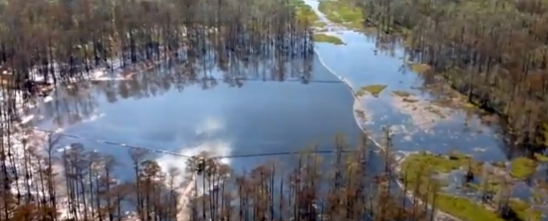
Disturbing new flyover videos of Louisiana sinkhole showed the amount
of land collapsed has increased in size. Last measurements show that
the surface of the sinkhole area was 5.5 acres, or equivalent of five
football fields. Based on John Boudreaux, director of Assumption Parish Department of Homeland Security and Emergency Preparedness stated that the surface is now closer to the size of six football fields according to the Examiner. The sinkhole occurred early on August 3 in swampland between Bayou Corne and Grand Bayou.
On October 30, a large slough in occurred at the sinkhole site . The
size was estimated to be a 20 feet by 80 feet section located on the
east side of the sinkhole according to Assumption Parish Police Jury.
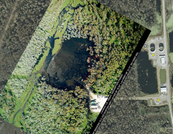
According
to Boudreaux, based on a pre-collapse, ground-based photograph of the
site and Google Earth-based mapping software used for aerial photographs
of the site before and after the Tuesday’s collapse, the area of
sinkhole increased to roughly 300 feet along the eastern bank and 100
feet inland, within 10 feet for irregularly shaped collapse zone.
However, responsible Texas Brine, disputed this figure, giving new
values of 50 to 75 linear feet of the sinkhole bank by 15 to 20 feet
inland, an area possibly as small as 750 square feet. On August 3, the
size of the sinkhole was said to be approximately the size of two
football fields.
Sinkhole slough in map from October 31, 2012 (Credit: Assumption Parish)
After shutting all pipelines, Department of Natural Resources
determined that pipelines are not cause of bubbles. Staff has reviewed
23 hydrocarbon storage and 36 brine cavern wells and associated cavern
files which represents 100% of the cavern wells on the dome bubbles.
Hydrocarbons and dissolved natural gas were confirmed in water at
slurry site. Results show slightly elevated chlorides at surface
samples, deep samples also shows elevated salinity as well as
indicators of natural gas. Results indicate petroleum hydrocarbons
dominated by diesel range organics, same as samples collected on August
4. Shaw E&I has confirmed the hydrocarbon material to be unprocessed
crude oil. As of 30 October, Texas Brine has removed 102 roll off
boxes hydrocarbon contaminated debris and approximately 935 barrels of
hydrocarbons from the surface of the sinkhole. Section for Environmental Epidemiology and Toxicology (SEET)
has received and is analyzing community ambient air sampled from August
28,2012 until October 30, 2012 (MultiRAE). SEET will issue a letter to
the parish in reference to these findings once the review of the data
has been completed.
Graphic showing sinkhole from above (Credit: DNR Louisiana/Public Briefing October 23, 2012.)
Earthquake connection?
USGS monitor seismic activity at the
six seismograph locations. According to USGS, an average of one tremor a
day is occurring, in the direction northwest of the sinkhole. In
response to Texas Brine’s assertion that region seismic activity caused
their cavern to be compromised, USGS stated on October 25 Sept. 2012
that it is their belief that the seismicity is a consequence of the
collapse of the cavern, and not the cause of the collapse of the cavern
and the formation of the sinkhole. Dr. Horton of the USGS stated the
science behind the recent events does not suggest a heightened level of
risk at this time. Dr. Gary Hecox with Shaw Environmental and
Infrastructure evaluated the readings from the USGS monitoring
equipment, following recent reports of seismic activity on the western
side of the Napoleonville Salt Dome. The Center for Earthquake Research and Information (CERI)
registered a short duration, pronounced seismic event at a depth of
approximately 500 meters (1,600 feet). After reviewing data from the
cavern pressure monitoring system and sinkhole bubble activity. Shaw
pointed that this event did not have any discernible effect on cavern
pressure or sinkhole bubble activity at the time. However, many
suspect extra drilling into the salt dome produced earthquake swarm in
the same area, six days before new collapse.
Storm along the central Gulf coast will move eastward to the eastern
Florida coast and deepen into nor’easter storm which will form off the
coast of South Carolina on Tuesday evening. The storm is forecasted to
accelerate north-northeastward on Wednesday, with a central pressure
expected near 984 mB . The system is expected to travel northward
paralleling the east coast northward to off the Delmarva Peninsula by
Wednesday morning. This will affect the areas that were hardest hit by
Hurricane Sandy last week. It should intensify into a medium-strength
nor’easter storm, pulling in cold Arctic air from Canada. As the storm
strengthens, winds are expecting to reach 95 to 115 km/h ( around 60 to
70 mph).
High, battering waves, could cause severe erosion along the coastal
areas pounded by Hurricane Sandy last week. Beach erosion caused by
Sandy and washed up sand dunes could hardly stop the surge, especially
along the New Jersey coastline. A storm surge of 2 – 4 feet would
likely hit the New Jersey coast, and a storm surge of 3 – 5 feet would
likely impact the western end of Long Island Sound.
At the present time, AccuWeather.com
meteorologists are expecting a 2 to 4-foot water rise on top of the
tide level from about Ocean City, Md., through Atlantic City, Belmar and
Sandy Hook, N.J. The worst of coastal flooding is expected Wednesday
afternoon and again late Wednesday night, as the hide tides appearing
that day. There isn’t much protection in place to hold the water back so
coastal residents are urged to take precaution against more rising
water.
Forecast rainfall totals for the next five days (Credit: NOAA)
Saturated ground will receive additional rain amounts which will lead to
flooding of low-lying and poor drainage areas, causing streams and
creeks to rise over their banks.
Nor’easter has the potential to bring more than a foot of snow to
mountain areas of New England. Additional power outages and damage to
trees will be likely due to the already soft saturated ground in place
across the region. About 1.26 million people are still without power in
the Northeast.
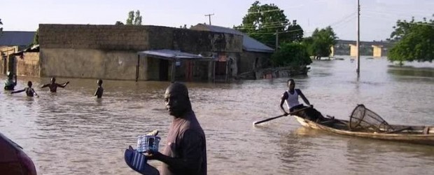
Since July, devastating floods affected 30 of the Nigeria’s 36 states, displacing more than 2 million people. The Nigerian Red Cross said
there’s no telling when families will be able to return, and when they
do, they will need help rebuilding their homes, and their
lives. Situation in camps is serious – there is severe lack of food and
clean drinking water. President Goodluck Jonathan has promised to
release additional funds for the procurement of medicine and seedlings
for victims, particularly those in Benue state. Punch reported that
severe hunger has hit over 400 children at Ula-Ehuda Camp in Ahoada
East Local Government Area of Rivers State. There is also a high risk of
epidemics breaking out in the affected areas.
Flooding started in
Plateau State in central Nigeria in July, spread through Borno, Cross
River, Ebonyi, Nassarawa, Bauchi, Gombe, Katsina and Kebbi states in
August, hit Taraba Benue, Niger, Kaduna and Kano in September, before
affecting Delta and Bayelsa states in September and October. The Benue
and Niger Rivers converge in southern Nigeria, and from there the Niger
flows south toward the sea.
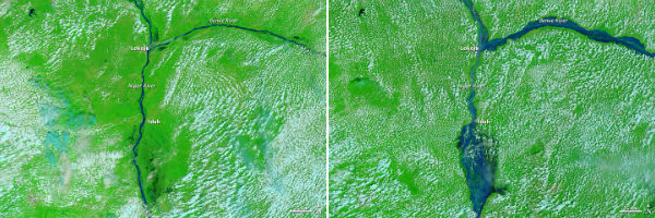
The Moderate Resolution Imaging Spectroradiometer (MODIS) on NASA’s
Terra satellite captured these images of the confluence of the Niger and
Benue Rivers on October 20, 2008 (left) and October 13, 2012 (right)
(NASA images courtesy LANCE MODIS Rapid Response Team at NASA GSFC.
Caption by Michon Scott)
According to the National Emergency Management Agency (NEMA), 431
fatalities have been reported and many more are considered missing. 2.1
million others were displaced. Floods caused major damage to crops,
livestock and infrastructure, destroying roads and bridges. According to
Emenike Umesi, NEMA’s zonal coordinator in Port Harcourt, thousands of
houses, health clinics and hospitals, as well as dozens of schools,
churches and government buildings have been destroyed or damaged in
Delta State. Many displaced residents are wondering why the government
has not done more to prevent flooding which occurs every year during the
August to October rainy season in these low-lying areas. Flash floods
are common in Nigeria in the rainy season (May to September), but news
reports characterized this year’s floods as the worst in more than 40
years. Rainy season is not over yet and more flooding is expected.
John Campbell,
a senior fellow at the Council on Foreign Relations and a former U.S.
ambassador to Nigeria wrote that the United Nations and other
organizations have “sounded the alarm” at the approach of similarly
large-scale humanitarian crises in the region, accusing Western media
for entirely ignoring the problem according to VOA.
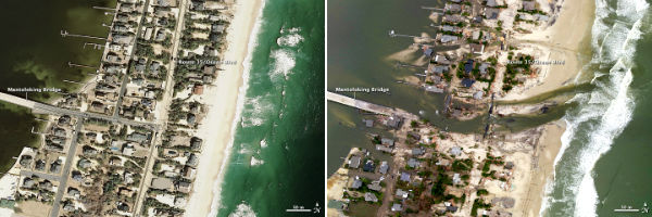
Portion of the New Jersey coastal town of Mantoloking, just north of
where Hurricane Sandy made landfall. The left image was taken on March
18, 2007 by the Remote Sensing Division of the National Oceanic and
Atmospheric Administration (NOAA) and the right image on October 31,
2012 acquired by the same group (Credit: Aerial photography courtesy of
the NOAA Remote Sensing Division. Caption by Mike Carlowicz)
A nor’easter is predicted to potentially hit the East Coast around
November 7 while it still recovering from devastation caused by
Hurricane Sandy. Nor’easters usually bring massive amounts of
precipitation, high winds, large waves, and marginal storm surge to
coastal areas. According to Brian McNoldy, a weather researcher at the
University of Miami, the new storm’s path is predicted to move from the
Southeast to New Jersey. The worst impact will be the coastal flooding
and beach erosion, backed up by strong winds and enhanced swells and
waves, regardless of how far off the coast system could be.
credit http://www.wunderground.com/
Fears of further beach erosion and coastal flooding
Experts
are concerned about further beach erosion, already devastated by
Sandy. Even if the new nor’easter system wont gain the strength as
Sandy, because hundreds of miles of dunes and protective seawalls tore
apart or eroded after Sandy’s impact, it could still lead to flooding
along lowland coastlines. Record surge and pounding waves
generated by Sandy destroyed hundreds of homes and buildings along the
East Coast. Rockaway Beach (on a peninsula in New York City’s borough of
Queens) was almost completely washed away and the boardwalk was
destroyed. Jones Beach (a barrier island off Long Island) was overwashed
by ocean. Gilgo Beach’s dune system (on Long Island) was almost
destroyed, and Ocean Parkway (which runs along the southern end of Long
Island) was overwashed. New Jersey’s Long Beach Island sustained severe
damage, with boats and cars tossed into streets and several feet of sand
piled against houses.
Increasingly vulnerable sandy beaches
Hilary Stockdon, a
research oceanographer with the U.S. Geological Survey in Reston, Va.
said the beaches and sand dunes are the first line of defense for
coastal communities against storm surge and waves. According to USGS,
many of the sandy beaches along the Atlantic Coast have
become increasingly vulnerable to significant impacts due to erosion
during past storms like Hurricanes Ida (2009) and Irene (2011), as well
as large storms in 2005 and 2007. USGS report released in February
2011 said that East Coast beaches have been steadily eroding for 150
years. The beaches in New England and the Mid-Atlantic are losing about
1.6 feet (0.5 meters) per year on average. The worst erosion case was
about 60 feet (18 m) per year at the south end of Hog Island, in
southern Virginia. The sandy Mid-Atlantic coast — stretching from
Long Island, N.Y., to the Virginia-North Carolina border — is eroding
faster than the rocky New England coast, the USGS report found. Still,
the majority of the coast is eroding throughout both regions, suggesting
erosion could become a bigger problem. Sandy’s late October
arrival also increased coastal vulnerability by removing sand that had
been naturally stored offshore for summer beach replenishment. During
the winter, sand is stored in sandbars and comes back in the summer.
Nor’easter
A nor’easter is a type
of macro-scale storm along the East Coast of the United
States and Atlantic Canada. This type of storm has characteristics
similar to a hurricane. More specifically it describes a low-pressure
area whose center of rotation is just off the East Coast and whose
leading winds in the left forward quadrant rotate onto land from the
northeast. The precipitation pattern is similar to that of
other extratropical storms. Nor’easters usually cause severe coastal
flooding, coastal erosion, hurricane force winds or blizzard conditions,
usually accompanied with very heavy snow or rain, depending on when the
storm occurs. Nor’easters can be devastating and damaging,
especially in the winter months, when most damage and deaths are
cold-related, as nor’easters are known for bringing extremely cold air
down from the Arctic air mass. Nor’easters thrive on the converging air
masses – the polar cold air mass and the warmer ocean water of the Gulf
Stream. The low enhances the surrounding pressure gradient, which
acts to spiral the very different air masses toward each other at an
even faster rate. The greater the temperature differences between the
two air masses the greater the turbulence and instability, and the more
severe the storm can become. Biologists at the Woods Hole
Oceanographic Institution on Cape Cod have determined Nor’easters are an
environmental factor for red tides of the Atlantic coast.
Every year in late October or early November, Earth passes through comet Encke’s wake, resulting in the well-known Taurid meteor shower. Because of their occurrence in late October and early November, they are also called Halloween fireballs. They are named after their radiant point in the constellation Taurus, where they are seen to come from in the sky. It is considered that this stream of matter, made up of pebbles instead of dust grains, is the largest in the inner solar system. Due to the stream’s size, the Earth takes several weeks to pass through it, causing an extended period of meteor activity, compared with the much smaller periods of activity in other showers.
Most years the shower is weak, producing no more than five rather dim
meteors every hour. But occasionally, the Taurids put on quite a show
and fireballs streak across the sky. (Credit: AstroCal)
The Taurids are commonly slow-moving meteors that blaze across the sky in pale orange colors. Typically, Taurids appear at a rate of about 7 per hour, moving slowly across the sky at about 27 km/s (17 mps ). Meteoroids the size of pebbles and small stones are producing a slow drizzle of very bright fireballs when entering Earth’s atmosphere. This year’s Taurid peak is expected during the nights of November 5-12. You can start skywatching at mid-evening on November 4-5, before the waning gibbous moon rises over your eastern horizon. You can see planet Jupiter low in the east. It shines in front of the constellation Taurus, the part of the sky from which the meteors appear to radiate. The Southern Taurids will peak on November 5, while the Northern Taurids will reach peak rates on November 12. The next meteor shower is the Leonids on the night of November 17.
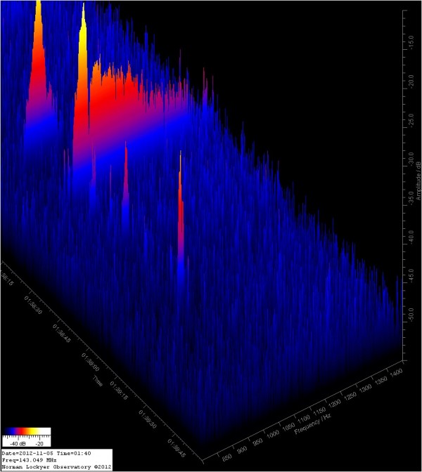
N.L.O. Meteor Detection Live View on November 5,2012 (Credit: MeteorScan)
Comet Encke
Comet Encke is thought
by some astronomers to be a piece of a larger comet that broke up 20,000
to 30,000 years ago. Comet Encke is believed to be the originator of
several related meteor showers known as the Taurids (which are
encountered as the Northern and Southern Taurids across November, and
the Beta Taurids in late June and early July). Encke orbits the Sun
every 3.3 years - the shortest period of any known comet. Given Encke’s
low orbital inclination near the ecliptic and brief orbital period of 3
years, the orbit of Encke is frequently perturbed by the inner
planets. The diameter of the nucleus of Encke’s Comet is 4.8 km.
This image taken by NASA's Spitzer Space Telescope shows the comet Encke
riding along its pebbly trail of debris (long diagonal line) between
the orbits of Mars and Jupiter. (NASA/JPL-Caltech/M. Kelley (Univ. of
Minnesota))
On April 20, 2007, STEREO-A observed the tail of Comet 2P/Encke to be
temporarily torn off by magnetic field disturbances caused by a coronal
mass ejection (CME). The tail grew back due to the continuous shedding of dust and gas by the comet.
The
origin of the Taurids was reexamined by Whipple and S. Hamid during
1950. They calculated the effects of secular perturbations by Jupiter on
the orbital inclination and longitude of perihelion of nine
photographic meteor orbits and found the orbital planes of four of the
meteors to coincide with that of comet Encke 4700 years ago. Three other
orbits coincided with one another, but not with comet Encke 1500 years
ago. The authors theorized “that the Taurid streams were formed chiefly
by a violent ejection of material from Encke’s Comet some 4700 years
ago, but also by another ejection some 1500 years ago, from a body
moving in an orbit of similar shape and longitude of perihelion but
somewhat greater aphelion distance….” It was suggested that this unknown
body had separated from Encke some time in the past.
In the orbital diagram, the location of Earth is denoted by a red splat.
The orbits of the meteoroids (yellow) roughly match that of parent
Comet Encke (orange), confirming their association with the Taurid
debris swarm.
Czechoslovakian astronomer Ľubor Kresák gave a theory that mysterious
Tunguska event of 1908 was in fact a fragment of Comet Encke. One
theory considers that impacts of Taurid debris fragments may have been
responsible for the Bronze Age collapse in the Fertile Crescent, perhaps
evidenced by a large meteor crater in Iraq. Ancient people may have
experienced Tunguska-type events, which occur approximately every 300
years as calculated by Eugene Shoemaker.
During the week ending
November 4, 2005, the large number of fireballs seen all over the world
led some to suggest UFO visitations. These fireballs may have been space
junk or the Taurids.